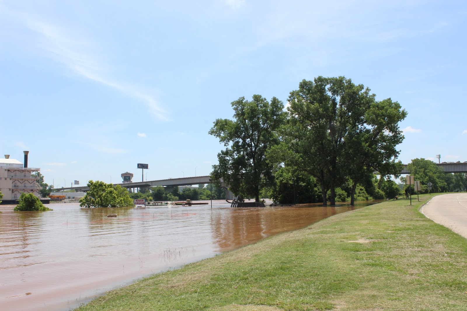
Today is the day it will crest; the Mighty Red will crest at 36.5, they say. At this moment it is at 36.39.
Nothing captures the devastation of this event like this new video from Sky Pixel LA;
Check out their page for more videos and photos.
One of the dangers now is the sightseers, which is one reason I haven't been back out with my camera. There are snakes, alligators and other critters that are in unexpected places. The sightseers are stopping on top of the Shreveport-Barksdale bridge in the lane of traffic to gawk. I know this because I was behind this person yesterday trying to drive to Bossier City. One woman I know nearly rear-ended a sightseer yesterday who had stopped on I-20 to look at the river.
On the KTBS page there is a video that shows how flooded the sheriff's substation is; and of course the reporter parked on the bridge to get the video.
It is astounding when you drive over one of the bridges and see all that water in places it should not be.
Here is today's graph:
June 7, 2015
The Bossier Parish Sheriff's page continues to post vivid photos including some yesterday of the rescue of some dogs from a flooded home.
As I said earlier, at this point drone pictures and other aerial photography is best as many streets are now flooded or blocked.
It is still possible to get to the Stoner Boat Launch though, which was my first stop today. To give a sense of perspective, this image from Google shows what the area normally looks like:
Stoner Boat Launch, Google Maps
You can see the Clyde Fant Parkway north and south bound over to the left. The parking lot at the top left is the VA overflow parking lot and parking for the Skate Plaza which you see next to the parking lot. Right now, if you drew a vertical line from the skate park straight down, everything to the right of that line is now water.
So, with that blue pavilion as a point of reference, here's the parking lot which is now a fishing pond:
Stoner Boat Launch, 6/5/2015
In that photo the blue pavilion is on the far right.
People were catching some very large fish out of there today.
Stoner Boat Launch, 6/5/2015
A butterfly was enjoying the rails at the skate park...
Butterfly!
Literally everywhere you go on the river people are taking pictures.
High water; Stoner Boat Launch
And the Clyde Fant Parkway is closed.
Turn around.
Undaunted, I put the shoe leather to work...
Clyde Fant Parkway, facing north
Well that would be the Frisbee golf course under water, and that water is getting awfully close to the road.
East and west sides of Parkway under water.
The walking path is well under water but this looks like a great fishing spot, now:
End of the road...
Downtown, things are not any better.
Riverview Hall is sandbagged.
Riverview Hall, 6/5/2015
The Parkway is closed downtown, too; the water is coming up through the drains in front of SciPort:
SciPort parking lot
Why the Parkway is closed:
Clyde Fant Parkway, 6/5/2015
Again, as a point of reference, these are the stairs I was using a few days ago. The barricades have been moved back closer to the street now, and they aren't letting anyone past them.
Riverview Park, 6/5/2015
The current is incredibly fast.
Red River
A now familiar reference point:
Near Riverview Park
City trucks not afraid of water:
Clyde Fant Parkway
Another familiar reference point:
River Cruise
SciPort is sandbagged:
SciPort sandbagged
And more photographers:
Clyde Fant Parkway
This sculpture is looking more like a watercraft these days:
Along Clyde Fant Parkway
You can see in this shot how close the water is getting to the road:
Clyde Fant Parkway
The J. Bennett Johnston Waterway Visitor Center:
Irony
You are no longer allowed on the viewing areas behind the Barnwell; it's all barricaded off now. Some city employees were behind the barricades looking at the river and some curious citizens went through the open barricade; this is the city employee chasing people off.
It's safe for me but not for you! Go away!
And a final shot from under the Texas Street bridge:
Thanks for the donations! It helps keep gas in the Jeep.
Stay dry and watch out for your neighbors. Be wary of things in the water. And there are several reports of livestock stranded as officials work rescue operations to save them. Be safe and help where you can.
Taking pictures of the river just got a whole lot more challenging unless you are a drone or a helicopter: both the Clyde Fant and the Arthur Ray Teague Parkways are closed.
The new projected crest is a foot higher than expected and crest is now expected at 36.5.
I'm going to see what kind of photos I can get today, but in the meantime, there are some great things online.
You can see the water getting very close to the Parkway toward the left side of the photo. The parking lot is entirely under water. The skate park and VA overflow parking lot appears okay in this picture.
This is why you don't build inside a levee:
River Bluff subdivision, Bossier (BPSO photo)
This is the Shreveport-Barksdale bridge and you can see the water gathering on the other side of the Parkway and War Veterans Home. This water was increasing and getting on the road which is why they closed the Parkway; they capped the culverts and are pumping the water back into the river.
Red River and Arthur Ray Teague Parkway (BPSO photo)
Clyde Fant Parkway is flooded in front of SciPort (KTAL photo)
Wells Island road:
Current status and projections:
Via KTBS, here are the road closures as of about 9:30 this morning:
.
Clyde Fant Parkway SB from Milam to Stoner Ave
Clyde Fant Parkway NB from Shreveport-Barksdale Hwy to Milam
Crockett Street EB from Spring Street to Clyde Fant Parkway
100 Block of Crockett Street to 600 block of Commerce Street
Hilary Huckaby III @ Russell Road
Holcomb Drive @ Old Blanchard Road
Jack Wells Boulevard / Clyde Fant Parkway to Airport Drive * 1 block
Wells Island Road /Mayfair
Russell Road/I-220
Nash Street, Bonnie Street, Gain Street, Hall Street - 1700 blk
Perrin Street / Hartman Street 2100 block
Dixie Shreveport Road - I-220 to George Road
Old Mooringsport Road- Dixie Shreveport to I-220
Russell Road-Hilary Huckaby III to Cross Bayou
Russell Road - Gain Street to Hilary Huckaby III
Here is today's round of flood pictures. I took these around 2:00 today and the river was at about 33.4 feet. Projected crest is 34.5 Friday or Saturday.
This first picture was taken from the top of Shreveport-Barksdale bridge, looking south. If you look at Saturday's pictures, you'll get a sense of how dramatic this is. This parking lot is now totally under water; that's the same parking lot I was walking around on two days ago.
Arthur Ray Teague Boat Launch parking lot
Another shot:
Arthur Ray Teague Boat Launch parking lot
There is overflow water on the opposite side of the Parkway:
From exit ramp, looking toward War Veterans Home
The Bossier Sheriff's Sub Station - flooded:
This is just south of the boat launch area; there is no parking and no fishing allowed now, so it's deserted.
Arthur Ray Teague Parkway, just south of boat launch
This is from the top of Jimmie Davis bridge:
From atop the Jimmie Davis bridge, looking north
This is overflow in the grassy area at the base of the Jimmie Davis bridge on the Shreveport side.
Overflow on Shreveport side
The water is on the shoulder of the road as you make the exit around toward Clyde Fant. At about 10:00 in the above picture, the water is on the shoulder.
They are still fishing on the Shreveport side, but you can't park on the side of the road.
Catching fish
We could see the fish jumping in the water.
I took this from the entrance drive at Hamel's Memorial Park, looking south:
From Hamel's Memorial Park looking south
Again, you could really see fish jumping!
The boat launch at Hamel's:
Hamel's boat launch
This is the Stoner boat launch; what you see in this picture is the walking path I was on day before yesterday is now under water...
This path was not under water 72 hours ago.
But, people are still fishing here:
Fishing in the parking lot.
River watching remains Shreveport's new hobby; the city workers were checking things out:
The water should be well beyond that tree line...
The frisbee golf course is now taking on water:
Frisbee golf course, looking south from the footbridge
And into the parking lot...
Parking lot, frisbee golf course
I'm not sure who "Big Swole" is but maybe they mean the river...
Okay, so at Riverview Park, all of the terraced areas are now under water.
A ridiculous amount of water
It's hard to get a sense of how fast this current is moving, but look at the water crashing against the bridge supports:
A very swift current
Day before yesterday I took these stairs...not today...
And apparently we are protecting some very important electrical stuff...
Sandbags
Don't worry...I won't...
A suddenly unnecessary sign
See the bird?
Where's the bird?
Here he is...
Two birds
The birds are cool but you see that scalloped stuff sticking out of the water? That's supposed to be a panel fence; it is ridiculously submerged.
And this bird is catching a ride on a floating tree:
Riding the current
Self explanatory:
Blub
This shot shows the steep incline at the casino:
That's the casino entrance behind the trestle
And the sightseers are out in force
No worries...
I do love the egrets...
So cute...
This looks more than ever like a fishing cork...
No cruisin' today...
You can check river levels here. As I write this it is at 33.5; it went up a little since I started this post.